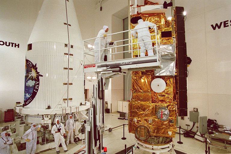
NASA will stop collecting new science data from its Terra satellite on Dec. 1, ending a record of Earth observations that began in 2000. The spacecraft's archive will remain free and public.
The Nov. 17 announcement sets out two stages: science observations end first, then the team uses remaining fuel to lower the orbit before switching off spacecraft systems in January 2027. NASA cites aging systems and an orbit that is drifting.
Terra has helped document land use, wildfire smoke, ice and the atmosphere. Its retirement changes a source behind familiar Earth images and scientific measurements. Other satellites continue observing those subjects, with differences in when and how they look.
The current cutoff replaces older projections
Readers may encounter different dates in NASA's older material. An editor's note on the agency's December 2025 retrospective projected Terra's end of science for February 2027. The new Nov. 17 notice gives Dec. 1, 2026.
Terra launched from California on Dec. 18, 1999, on a mission designed to last six years. NASA stopped making the inclination adjustments that maintained its orbit in 2020. As a satellite's crossing time changes, it observes the same landscape under different lighting and at a different point in the day's weather cycle.
The new announcement also says MOPITT, the carbon monoxide instrument, and parts of CERES and ASTER had already been shut down to conserve power.
Five instruments recorded different parts of Earth
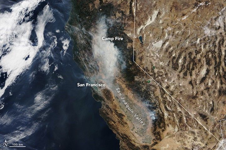
MODIS, the Moderate Resolution Imaging Spectroradiometer, supplied broad views of land, ocean and the lower atmosphere across 36 spectral bands, or ranges of wavelengths.
The other instruments added measurements a conventional color picture cannot provide. ASTER recorded detailed surface information, including temperature and elevation. CERES measured Earth's radiation budget. MISR viewed the planet from multiple angles to study clouds, particles and surfaces. MOPITT measured carbon monoxide in the lower atmosphere.
For example, Terra's Nov. 9, 2018 observation of California showed smoke from the Camp Fire spreading widely. Such records let researchers revisit how an event developed years after the satellite passed overhead.
What VIIRS can continue
NASA's MODIS-to-VIIRS transition guide describes datasets designed to continue cloud and aerosol records. VIIRS, the Visible Infrared Imaging Radiometer Suite, flies on NOAA-20 and NOAA-21.
The instruments make different tradeoffs. VIIRS has a wider viewing swath and some finer-resolution bands, but 22 spectral bands compared with MODIS's 36. It lacks some infrared bands used for temperature and moisture profiling. A sharper-looking image therefore does not establish that every MODIS measurement has a direct replacement.
Orbit timing also limits continuity. The guide points Aqua MODIS users toward VIIRS satellites in similar afternoon orbits. It says no MODIS-like instrument with Terra's morning equatorial-crossing time exists among current or planned NASA-managed missions.
Fire monitoring continues across several systems

The Copernicus Atmosphere Monitoring Service began adding VIIRS observations to its global fire assimilation system in December 2025. Its February 2026 account also described work to incorporate morning Sentinel-3 observations.
Satellite pictures need context when judging smoke. In an October 2023 NOAA-20 image, a plume extended down the U.S. East Coast. NASA reported that the smoke's height limited its effect on surface air quality, despite its visibility from space.
Where to find the archived images and data
NASA's Worldview and Worldview Snapshots let readers browse satellite imagery and select regions, including U.S. states. Worldview also connects users to underlying data through Earthdata Search.
For a historical event, select its observation date and check the satellite and instrument attached to the image. Those labels distinguish a Terra record from another mission's view.
For current imagery, allow for processing. The service says current-date images are available about three hours after acquisition. NASA's Worldview instructions also note that a selected region may have no image yet because the satellite has not passed overhead or processing is incomplete.